
The isle of wight geology is one of the most remarkable geological landscapes in the United Kingdom. It showcases an extensive record of Earth’s history spanning over 130 million years, from the Early Cretaceous to the Palaeogene periods. This island’s rock formations, cliffs, and bays reveal the dynamic processes of sedimentation, erosion, and tectonic activity, making it a prime location for both researchers and visitors interested in geology and natural history.
The isle of wight geology also stands out for its accessibility and clarity. Coastal erosion and landslips have exposed continuous layers of sedimentary rocks, allowing for an almost textbook view of geological processes. From the chalk ridges to fossil-rich clays, this region provides a living laboratory for understanding how landscapes evolve over millions of years.
Geological History of the Isle of Wight
The geological history of the isle of wight geology begins in the Early Cretaceous period when rivers and shallow seas deposited sands, clays, and silts across a low-lying landscape. These sediments gradually hardened into sandstone, clay, and mudstone, forming the foundations of the island. Later, during the late Cretaceous, thick deposits of chalk accumulated from microscopic marine organisms, creating the island’s prominent chalk ridges and downs.
Tectonic activity, particularly during the Alpine Orogeny, caused folding and faulting across the island. This event tilted the rock layers, forming the distinct east–west chalk ridge and dramatic cliffs that define the coastline today. The isle of wight geology therefore displays a clear contrast between older southern Cretaceous rocks and the younger Palaeogene formations in the north, offering insight into millions of years of Earth’s tectonic and sedimentary history.
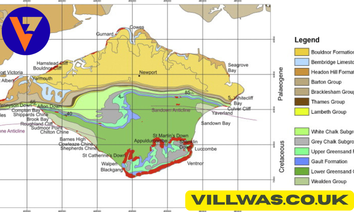
Isle of Wight Geology Map and Cross Section Explained
Understanding the isle of wight geology is greatly aided by studying its geological map. The southern half of the island is dominated by Cretaceous chalk and Wealden clays, while the northern region contains Tertiary sands, clays, and limestones. The map highlights the distribution of these formations and provides critical information for researchers, fossil hunters, and students aiming to interpret the island’s geological history accurately.
A cross section of the isle of wight geology shows how layers dip steeply along the central chalk ridge, forming monoclines and folds. These visible geological structures help explain the island’s steep cliffs and valleys. By combining maps with cross sections, geologists can visualise the three-dimensional structure of the landscape and better understand how natural forces shaped the island over millions of years.
The Chalk Ridge and The Needles
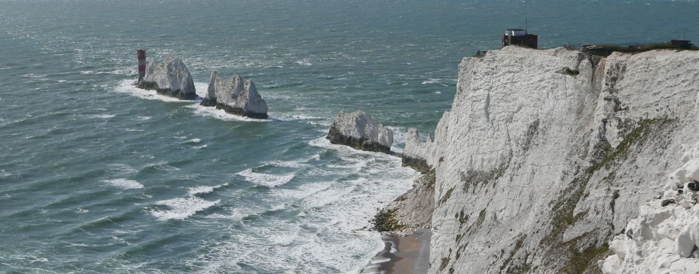
One of the most striking features of isle of wight geology is the chalk ridge that stretches across the island from east to west. These chalk formations were deposited during the late Cretaceous period and consist of compressed microscopic marine organisms. Over millions of years, these layers were uplifted, folded, and exposed, creating the rolling downs and steep cliffs seen today.
At the western tip of the island stand The Needles, iconic chalk stacks rising dramatically from the sea. These formations were originally part of the main chalk ridge but have been isolated by erosion and wave action. The Needles are an excellent example of the effects of coastal processes on chalk landscapes, demonstrating the ongoing interaction between geological structures and natural forces.
Freshwater Bay Isle of Wight Geology
Freshwater Bay offers some of the clearest exposures of the isle of wight geology along the southern coast. Here, steep chalk cliffs reveal folded layers and sharp stratification, showcasing the effects of tectonic movements. Freshwater Bay is particularly valued for its educational potential, providing an accessible site for field studies and geology enthusiasts.
The chalk and sandstone formations at Freshwater Bay also contain fossil-rich layers. Fossil hunters can discover ammonites, shells, and other remnants of ancient marine life. Coastal erosion continues to expose new sections, meaning that the isle of wight geology remains dynamic, providing fresh insights into Earth’s history while attracting visitors and researchers alike.
Fossils and the Dinosaur Legacy
The isle of wight geology is famous for its wealth of fossils, particularly in the Wealden Group of southern deposits. Dinosaur remains, footprints, and other prehistoric fossils have been found across the island, earning it the nickname “Dinosaur Island.” These discoveries provide critical evidence of life in the Cretaceous period and help scientists understand ancient ecosystems.
Institutions like the Natural History Museum have long studied these fossils. Alongside dinosaur bones, fossils of ammonites, plants, and marine organisms offer a comprehensive view of prehistoric life. The fossil record enhances the significance of isle of wight geology, attracting academic research and making the island an important centre for palaeontological study in Europe.
Coastal Features, Landslips and The Undercliff
The southern coastline of the isle of wight geology is dominated by landslip areas, particularly the Undercliff, one of Europe’s largest coastal landslip complexes. These features formed when soft clay layers became saturated with water, causing the overlying rock to slide. The resulting landscape is a mixture of terraces, cliffs, and unstable slopes that continues to evolve with time.
These landslips are important both ecologically and geologically. They create unique habitats for flora and fauna and demonstrate the ongoing interaction between geology, climate, and human activity. The isle of wight geology shows that landscapes are not static but continuously shaped by natural forces, highlighting the importance of monitoring and conservation.
Environmental and Scientific Importance
The isle of wight geology offers invaluable insights into ancient climates, sea-level changes, and biodiversity over millions of years. Researchers study these rock formations to understand long-term environmental shifts, helping to inform climate science and conservation strategies. The island’s exposed layers make it an ideal location for field studies, attracting universities, schools, and amateur geologists.
Protected landscapes ensure that the isle of wight geology remains accessible for future generations. Conservation efforts preserve key sites, allowing both scientific research and public education to thrive. This combination of natural beauty and scientific value makes the island a unique repository of geological heritage in the UK.
Conclusion
The isle of wight geology is one of Britain’s most significant geological treasures. Its chalk ridges, fossil-rich clays, dramatic cliffs, and dynamic coastal landscapes tell a story spanning over 130 million years. Each formation, bay, and cliff contributes to a deeper understanding of Earth’s history and natural processes.
From The Needles to Freshwater Bay, isle of wight geology continues to attract scientists, students, and tourists alike. Its enduring educational, scientific, and scenic value ensures that it remains a celebrated natural landmark, illustrating the profound beauty and complexity of geological evolution.
Frequently Asked Questions
What is Isle of Wight Geology?
The study of the island’s rock formations, fossils, and landscape history.
Where can I see Freshwater Bay Isle of Wight Geology?
At Freshwater Bay, with visible chalk cliffs and fossil layers.
What is special about The Needles Isle of Wight Geology?
Dramatic chalk stacks formed by erosion of the central chalk ridge.
How do I read an Isle of Wight Geology map?
It shows the distribution of Cretaceous and Tertiary rock formations.
Where can I find an Isle of Wight Geology cross section?
Visible along western cliffs showing folded and tilted rock layers.
Why is Isle of Wight Geology famous for fossils?
It contains dinosaur bones, ammonites, and plant fossils from the Cretaceous.
What is the Undercliff in Isle of Wight Geology?
A large landslip area formed by clay layer movement and coastal erosion.
Also Read: Components of a Semaphore Signal